Traveling The Yukon Quest Trail as a Handler or Spectator
First and foremost, please be good neighbors! The Yukon Quest is a huge event that passes through small communities once a year. Respect the fact that many people live in these communities and are just trying to go about their lives despite the race that is going on. Also, please spend some money at their local businesses to boost their economy as a means of saying thank you for allowing us to continue to use their facilities. We couldn’t put together races every year without these communities!
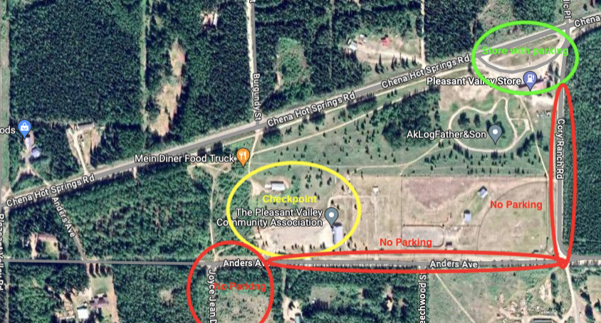
Two Rivers/Pleasant Valley Checkpoint
Getting There
- The checkpoint is located at the Pleasant Valley Community Center at mile 23.5 of Chena Hot Spring Road.
- Although the speed limit on Chena Hot Springs Road in the area is 45 or 50 mph, with all the commotion, people pulling off on the side of the road, and the signs we put out for the crossing, it seems like generally everyone slows down a lot to 25/30 mph in the area, and that is definitely preferable.
- There aren’t many places to pass safely in this area so if someone is really slow they should pull off onto a side road to let others pass.
- EVERYONE SHOULD ALWAYS KEEP AN EYE OUT FOR DOG TEAMS! The trail crosses a bunch of these side roads and theses crossings are NOT regulated.
- The trail crosses Chena Hot Springs Road at mile 27. This crossing is controlled by volunteers, however, vehicles should assume that a team is coming, and proceed with extreme caution.
- There is cell service at the checkpoint, but, it gets spotty pretty quickly down near the road crossing.
Parking
- Parking is extremely limited! The checkpoint DOES NOT have room for parking for anyone besides the handlers, volunteers, and race officials.
- Cory Ranch Road and Anders Ave (see above map) are very narrow and it would be best if no one parked on those so handlers, volunteers, and race officials can come and go from the checkpoint. The dog teams come in from Joyce Jean Drive, so cars should not be parking over there either.
- Be considerate that people live on all the streets in the area and may be trying to just go about their life. Parking at the Pleasant Valley Store and the little shopping area by Missing Moose are the best options.
Places to Eat
- The Pleasant Valley Store, right next to the checkpoint, (open 9am-8pm) has gas and some convenient store type items.
- The Missing Moose Cafe (open 9am – 4:30/5pm) has coffee and food as well.
- Wagner’s Pizza Bus, on Anders Ave. off Zuendel St. at mile 24 CHSR 1-8pm on weekends.
Mile 101 Checkpoint
Getting There
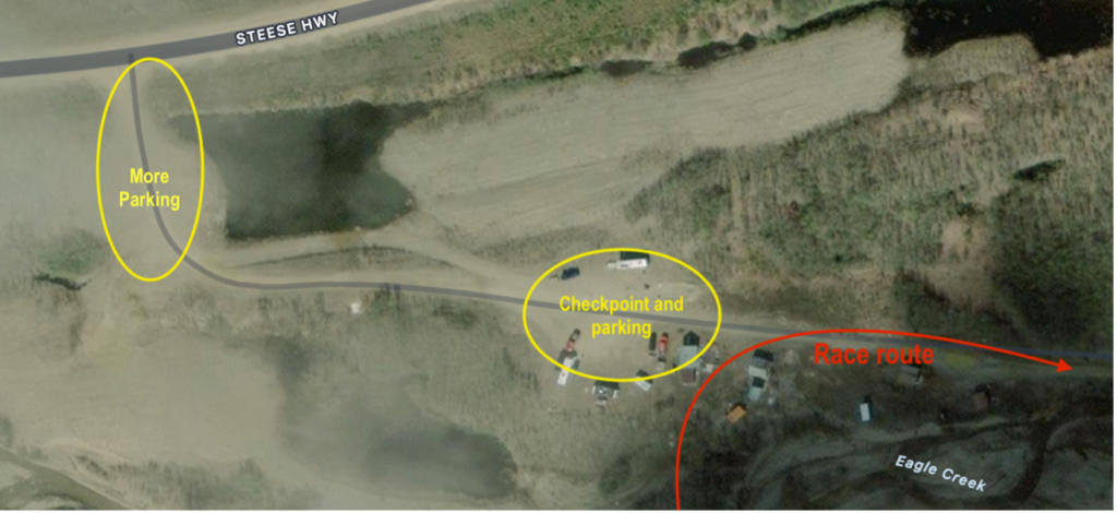
- Located at mile 101 on the Steese highway, between 12-Mile and Eagle Summit.
- There is no cell service past about mile 22 on the Steese highway, and very little in the way of help. Be prepared for winter driving: bring arctic gear with you, a shovel, spare tire, gravel, and extra food and water. Another means of communication (sat phone or GPS device) is strongly recommended.
- The Department of Transportation maintains the road during the day, but in the evenings and over night, there is no regular maintenance.
- The summits are treacherous even for people who are very comfortable with rural Alaska driving; they are notoriously windy and drifts accumulate on the road very quickly.
- Convoying up with other vehicles is the safest means of travel.
- A lottery-only caribou hunt will begin the day before the race. There will likely be lots of vehicles on the road having nothing to do with the race, and probably some of them will be parking at 101.
Checkpoint
- The checkpoint itself consists of an ATCO trailer generously donated by Summit Logistics, and an Arctic Oven tent for musher sleeping, powered by a generator.
- There are cabins on the site, but they are off-limits because of permitting.
- Parking in front of the ATCO trailer is for vets and officials. The way this driveway is set up, it gets congested very easily. Please be courteous about leaving a path for people to turn around and leave. This may mean walking up to the checkpoint from the lower pull-out.
- There are no food options for handlers or spectators here due to the temporary nature and lack of infrastructure of the checkpoint.
Central Checkpoint
Getting There
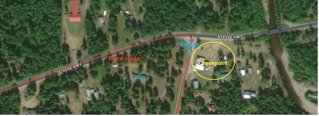
- Located at “the Corner” – Gold Country Services restaurant/bar/hotel – at the intersection of the Steese Highway and Circle Hot Springs Rd in Central, AK
- Eagle Summit is a windy, cliffside road. Drive at your comfort level, and use pullouts when necessary.
- The trail crosses the road at mile 116.3 on the north side of Eagle Summit. This is an uncontrolled crossing. BE AWARE OF YOUR LOCATION AND WATCH FOR DOG TEAMS!
- The trail comes onto and follows the road a mile before the checkpoint. DO NOT TRY AND PASS A TEAM IN THE ROAD.
Checkpoint
- Parking is extremely limited in front of the restaurant. Parking on the road is preferable, but please make sure that there is ample room for vehicles and teams to move around, both on the Steese Hwy and Circle Hot Spring Rd, as teams will come from both directions during the race.
- This is a both a checkpoint and the finish line for both the 200 and 300 mile races, so there will be a lot of activity.
- Gold Country Services serves as the checkpoint headquarters. It is a restaurant, bar, convenience store, and gas station. They are very busy during the race; please make a suitably-sized purchase to “pay” for your table.
Circle City Checkpoint
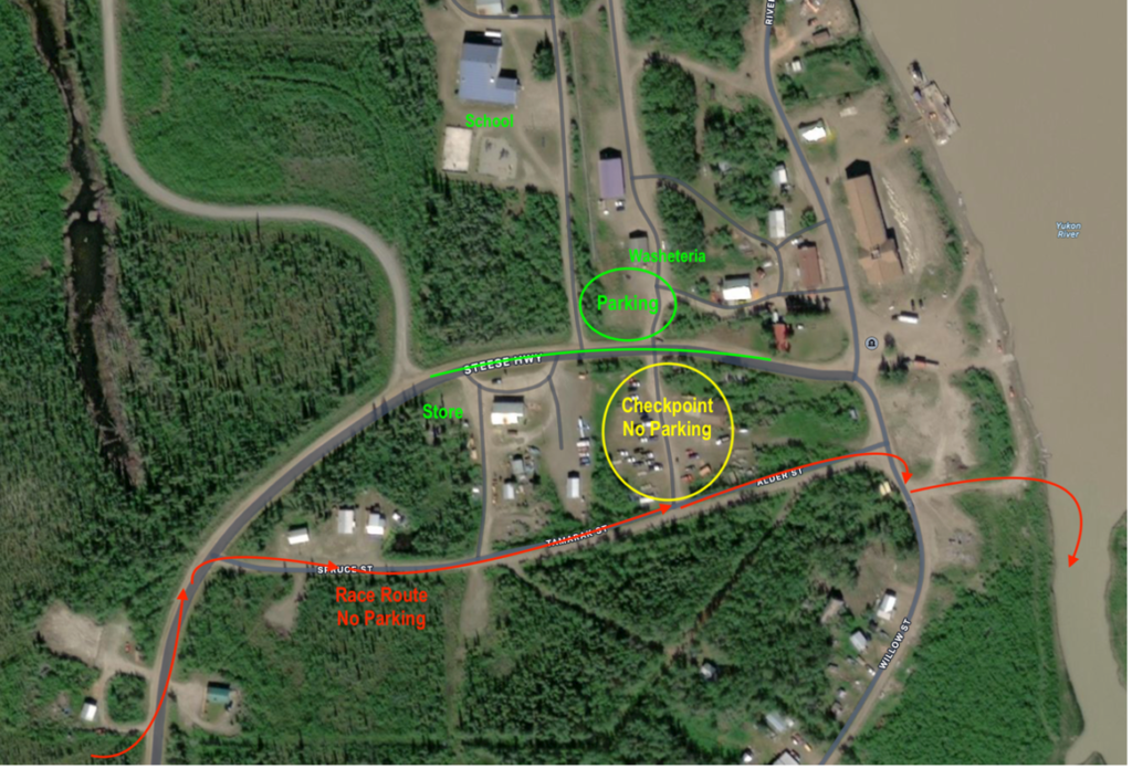
Getting There
- The distance from Central to Circle is only 34 miles, but the road is very twisty and windy – it takes every minute of an hour to make that trip, longer if the road is slick.
- The bridge over Birch Creek midway between the two villages is a great place to watch teams come through. Do not stop on the bridge, but park on either side and walk.
- The trail comes onto the road just before town, and passes along the smaller roads to the firehall.
- Locals live on these smaller roads and will be driving along the same route as the trail, but visiting vehicles should stay on the Steese Highway and come along the back side of the checkpoint.
- Only vets and officials will be allowed to park in the checkpoint area in front of the firehall. Parking is available on the Steese, and in the open area next to the washeteria. Please leave sufficient room for vehicles and potentially dogs teams to pass through.
- Expect hunters in the parking lot near the river.
Facilities in Circle
- Sonya’s Bed and Breakfast on the outside of town has a few rooms available (907) 773-8272 or (907) 750-8260 and on Air BnB.
- HC general store has general convenience items and fuel is available. Hours: 8am to 6pm (907) 773-1222
- The school is offering sleeping space in the gym for a small fee, as well as internet access and bolt head plug-ins for donation (907) 773-1250. They will also be having a bake sale and will have a spaghetti dinner available for donations.
- Amanda Pope is selling pizza and pizza sandwiches in the Circle Firehall during the race.
Know Before You Go – 2024 Checkpoint Information